Geology of the Chalybeate Topographic Quadrangle,
Tippah and Alcorn Counties, Mississippi
Charles T. Swann
Mississippi Mineral Resources Institute
220 Old Chemistry Building, University, Mississippi 38677
The Chalybeate 7.5 minute topographic quadrangle encompasses parts of Tippah and Alcorn
Counties of Mississippi, and the southernmost parts of Hardeman and McNairy Counties,
Tennessee. The mapping described herein has produced the first 1:24,000 scale geologic map for
the area within the confines of the quadrangle. The oldest exposed stratigraphic unit is the
Cretaceous Ripley Formation, cropping out in the eastern half of the quadrangle. The Ripley has
been subdivided elsewhere into the McNairy Sand and the Chiwapa Sandstone Members;
however, only the McNairy Member can be recognized in the study area. This lack of a mappable
Chiwapa lithology has required that it be mapped with the McNairy as one unit, i.e., the McNairy
Sand Member of the Ripley Formation. Unconformably above the Ripley is the Cretaceous Owl
Creek Formation, which consists of 2030 feet (6.19.1 m) of fossiliferous sands and silty clays.
The upper Owl Creek contact is the unconformable CretaceousTertiary boundary. The Clayton
Formation is the basal Tertiary unit and consists of 5080 feet (15.224.4 m) of glauconitic sands
with a discontinuous basal limestone. The Porters Creek Formation conformably overlies the
Clayton and consists of gray clay and silty clay. At least two sets of elevated, fluvial terraces are
present and are tentatively assigned a Quaternary age. Recent flood plain deposits, which are
associated with most of the existing fluvial systems, were also mapped. The major structural
component consists of a northeasternly-trending fault zone along Muddy Creek. The primary
fault is a high angle normal fault having an estimated 50 feet (15.2 m) of displacement with the
upthrown block on the east. One associated normal fault can be mapped and others probably
exist, but cannot be mapped due to lack of exposures. A set of joints has also been measured in
the fine-grained Owl Creek and Clayton Formations.
An early geologic map of Tippah County was published by Conant and McCutcheon in 1941 as part of a state-wide mapping effort. Since this map was the first for the county, it made a significant contribution to our knowledge of the geology of the area. The adjoining Alcorn County has never been geologically mapped in a systematic manner. The Conant and McCutcheon map was generalized and incorporated into the Geologic Map of Mississippi published by the Mississippi Geological Survey in 1969. Russell and Parks (1975) included the northern quarter of the study area as part of their mapping in Tennessee, but did not include the area south of the MississippiTennessee state line in their published geologic maps. No geologic mapping has been carried out at the 1:24,000 scale over the entire Chalybeate Quadrangle prior to the work reported herein.
As more accurate means of establishing the vertical and horizontal position of formational contacts have become available, more accurate geologic maps can be constructed. In coastal plain terrains outcrop belts are strongly influenced by topography making the vertical control available through use of standard topographic maps a major factor contributing to improved geologic maps. The Chalybeate Miss.Tenn., 7.5 minute topographic quadrangle, published by the U.S. Geological Survey in 1982 with a contour interval of 20 feet (6.1 m), was used as a base map on which contacts, outcrop and well locations were plotted. Geophysical well data, field data and standard three point projections of contacts were used to establish the outcrop belts denoted on the geologic map.
This investigation is part of the Mississippi Mineral Resources Institute's (MMRI) efforts to provide to the public new geological data that it will find immediately useful. In order to encourage public use of this geologic map, it is available as paper copy or as a digital Arc/Info file (Arc/Info is a geographic information system produced by Environmental Systems Research Institute, Redlands, California) through the MMRI offices at 220 Old Chemistry Building, University, MS 38677.
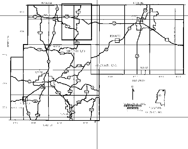
Area of Study--The Chalybeate quadrangle includes areas of northern Tippah and Alcorn Counties Mississippi, and the southernmost extremes of Hardeman and McNairy Counties, Tennessee (Figure 1). The primary focus of the study was the lithostratigraphy within the area encompassed by the quadrangle; however, additional field mapping was carried out in adjacent areas to ensure continuity across map boundaries. The study area is characterized by a rolling, upland topography with well developed, low relief, flood plains along the major streams. Total relief within the study area is approximately 300 feet (91.5 m).
Stratigraphy--The oldest stratigraphic unit cropping out in the study area is the McNairy Sand Member of the Upper Cretaceous Ripley Formation. The McNairy lithology is typically a medium-to-coarse-grained, cross-bedded sand. Ophiomorpha nodosa is the only fossil common to the unit. Several exposures in road cuts crossing the Hatchie River contain the typical McNairy lithology as well as a section of thin clay beds marking the middle of the McNairy. These clay beds thicken updip (eastward), become darker gray, and contain carbonized plant material. A well developed exposure of the middle clay section can be seen in a road cut along U.S. Highway 72, in the northern half of sec. 10, T2S, R5E.
In southern Tippah County, the Chiwapa Sandstone Member of the Ripley Formation is locally well developed between the McNairy Sand and the younger Owl Creek Formation (Swann, Faruque, and Harding, 1995). No Chiwapa lithology is noted from outcrops within the study area. There is, however, a zone at the equivalent stratigraphic position which contains a coarser grain size and may contain molds and casts of bivalves. This zone is the stratigraphic equivalent of the Chiwapa, but without the calcium carbonate cement, which is the main identifying characteristic of the Chiwapa. This "Chiwapa equivalent" is exposed near the headwaters of Jonesboro Creek (southern half of sec. 2, T2S, R4E) where echinoid plates and ammonite fragments are found below the lower Owl Creek contact and molds and casts of bivalves are found in iron oxide crusts in the banks of the creek. Since this more clastic "Chiwapa" is so similar to the McNairy lithology, it cannot be distinguished in most outcrops. For this reason, the "Chiwapa" is combined with the McNairy Sand unit for mapping purposes. The McNairy Sand is the most extensive map unit in the study area and approximately 50% of the map area is assigned to the McNairy.
The youngest Cretaceous unit, the Owl Creek Formation, unconformably overlies the "Chiwapa"/McNairy Sand. The lower contact is typically sharp, marked by the finer grain size and a zone of abundant Ophiomorpha nodosa in the Owl Creek. The unit often contains a thin, basal unit consisting of cross-bedded, fine-grained sands, with dark gray, fossiliferous, silty, sandy clays above. Because both the lower and upper formational contacts are unconformable surfaces, the thickness of the unit varies. The typical range of thickness within the study area is 2030 feet (6.19.1 m). Fresh exposures of the upper Owl Creek section can be found at Chalybeate Spring (in the town of Chalybeate, sec. 10, T2S, R4E). Although more weathered, the entire formation is contained in exposures along the south side of Fourth Creek (SW ¼, sec. 23, T2S, R4E), where undercutting has resulted in the slumping of the creek banks. Both the Fourth Creek and the Chalybeate Spring exposures contain a diverse molluscan fauna. The Owl Creek outcrop belt comprises approximately 12% of the study area.
The Clayton Formation, the oldest Tertiary unit, unconformably overlies the Owl Creek Formation. The Owl Creek-Clayton contact is marked by a grain size change from the fine-grained silts and clays of the Owl Creek to the coarser clastics of the Clayton. In the Chalybeate Spring exposures, the basal Clayton consists of a thin, coarse-grained, gravelly sand. Above the basal clastic unit is a discontinuous, sandy, phosphatic limestone which in places contains abundant molds and casts of Turritella mortoni. Medium- to fine-grained glauconitic sands lie above the limestone and may comprise almost the entire unit where the limestone facies is not present. Poorly preserved, silicified, bivalve fossils are occasionally found in the highly weathered outcrops of the glauconitic sand facies. The thickness of the Clayton is at a maximum in northern Tippah County and thins southward along strike. Connant and McCutcheon (1941) suggest a thickness of as much as 80 feet (24.4 m) in the study area; but a thickness of 50 to 60 feet (15.218.3 m) is more common.
Along the southern extreme of the study area, the Clayton has locally overstepped the Owl Creek Formation, a reflection of the unconformable lower contact. Stratigraphic oversteps of the Clayton have also been suggested by Russell and Parks (1975) to explain what they interpret to be the Clayton Formation resting on McNairy Sand in Tennessee. In the Chalybeate quadrangle, this stratigraphic overstep consists of a paleochannel complex developed on the Cretaceous - Tertiary unconformity. The channel facies extends eastward beyond the normal Clayton outcrop belt across the entire Owl Creek outcrop belt and onto the McNairy Sand. The paleochannel is better developed in the adjoining Falkner and Peoples quadrangles (to the southwest and south of the Chalybeate Quadrangle, respectively), where the channel contains well rounded quartz gravel and sandstone cobbles up to 7 inches (17.8 cm) in diameter.
The Chalybeate Spring exposures in the town of Chalybeate comprise the type section of the Chalybeate Member of the Clayton Formation. Unfortunately, only the basal clastics and the phosphatic limestone lithologies are available for study, the rest of the section is covered by vegetation. When the type section was originally set up by MacNeil (1946), he proposed that the Chalybeate Member be defined as a predominantly clastic unit, in contrast with the more carbonate-rich (chalk) lithologies further south along the Clayton outcrop belt in Mississippi. The Chalybeate Member was mapped, therefore, as an equivalent to the entire Clayton section. This assignment is representative of the lithologies of the type section as set up by MacNeil (1946) and reflects his concept of the clastic nature of the member. This interpretation of the Chalybeate is also in agreement with the recent revisions of the generalized stratigraphic column of Mississippi as described by Dockery (1996). The area assigned to the Clayton outcrop belt is approximately 13% of the study area, similar to the area of the Owl Creek outcrop belt at 12%.
The Porters Creek Formation lies conformably above the Clayton Formation. The contact is placed at the base of the lowest clay bed above the glauconitic sands of the Clayton. In general, the Porters Creek Formation is finer grained than the underlying Clayton Formation. The ClaytonPorters Creek contact is poorly exposed in the study area and only a limited extent of the Porters Creek Formation is present in the northwestern corner of the quadrangle (less than one percent of the total study area).
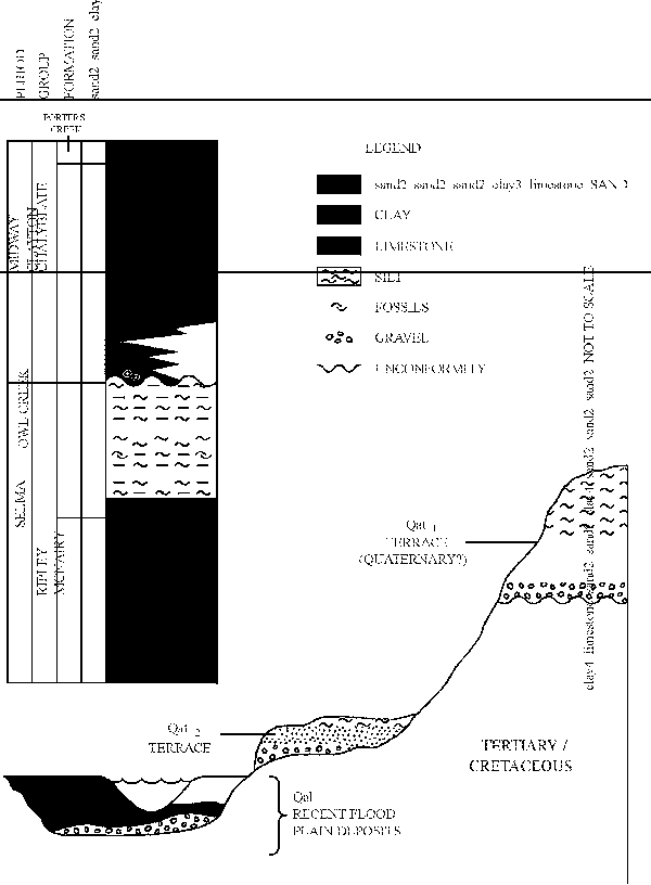
There are three Quaternary units mapped within the study area (Figure 2). The oldest unit (Qat1) is an outlier of terrace material on the eastern edge of the study area. This outlier (in portions of sections 22, 23, 26 and 27, T1S, R5E) consists of a fining-upward sequence with sand and gravelly clay at its base and silts at the top of the sequence. The base of this unit is estimated to be at an altitude of approximately 590 feet (179.9 m). This elevation suggests a correlation with the "ridge top" outliers reported by Parks (1992) near Hebron, Tennessee, which have a basal elevation of 580 feet (176.8 m). In this report, a Quaternary age is assumed for this outlier; however, without an existing age determination, Parks' suggestion of a Pliocene age may be equally appropriate.
A lower set of terrace outliers (Qat2) crop out near the Hatchie River and are probably abandoned flood plain deposits of the Hatchie. The northernmost outlier extends northward from Mississippi (in portions of sections 17, 18, and 19, T1S, R5E) into Tennessee. South of Bearman Creek is another outlier which may have been continuous with this northernmost outlier prior to the present erosional cycle. In the southern half of the study area are five more terrace outliers which are included in this terrace classification. All of these outliers consist of a fining-upward sequence with gravelly sand at the base and silts at the top. Subangular clasts of iron-oxide cemented sandstone are diagnostic of this set of terraces. These clasts appear to be very similar to the iron oxide crusts which commonly form in the highly weathered McNairy exposures, suggesting that a component of the source area was to the east in the McNairy outcrop belt.
These terraces lie at elevations between approximately 460 feet (140.2 m) and 490 feet (149.4 m), intermediate between the Qat1 terrace and lower, modern flood plains. The outliers with basal elevations near 490 feet (149.4 m) suggest a correlation with Parks' "Terrace Deposit D." Basal elevations of the other outliers are not as easily fitted to Parks' classification scheme, as they are intermediate between the basal elevations of the "C" and "D" terraces. Detailed drilling and the northward tracing of terrace outliers along the Hatchie valley will probably be required to establish reliable correlations with the better known Mississippi River terraces or those described by Parks (1992). The age of these terrace outliers has not been determined, but they are assumed to be Quaternary. The combined area of the Qat1 and Qat2 terraces comprise less than three percent of the study area.
Most of the existing fluvial elements of the study area are associated with a well developed flood
plain. The flood plains associated with Muddy Creek and the Hatchie River are especially well
developed. These flood plain deposits are poorly exposed in stream banks. Although there is
significant variation in lithology, the flood plains typically consist of fining upward sequences with
sand at the base and clays and/or silt at the surface. These flood plains comprise 22% of the study
area. Table 1 summarizes the area of the outcrop belts within the confines of the study area.
| Table 1. Area of Outcrop Belts of Stratigraphic Units in the Study Area | |||
| Age | Stratigraphic Unit | Area of Outcrop Belt
(in acres) |
Area of Outcrop Belt
(percent of study area) |
| Quaternary | Existing flood plains (Qal) | 8,555 | 22 |
| Quaternary | Terrace (Qat2) | 727 | 2 |
| Quaternary (?) | Terrace (Qat1) | 185 | < 1 |
| TertiaryPaleocene | Porters Creek Fm. (Tpc) | 154 | < 1 |
| TertiaryPaleocene | Clayton Fm. (Tcl) | 4,993 | 13 |
| Cretaceous | Owl Creek Fm. (Koc) | 4,817 | 12 |
| Cretaceous | RipleyMcNairy Sand
(Krms) |
19,677 | 50 |
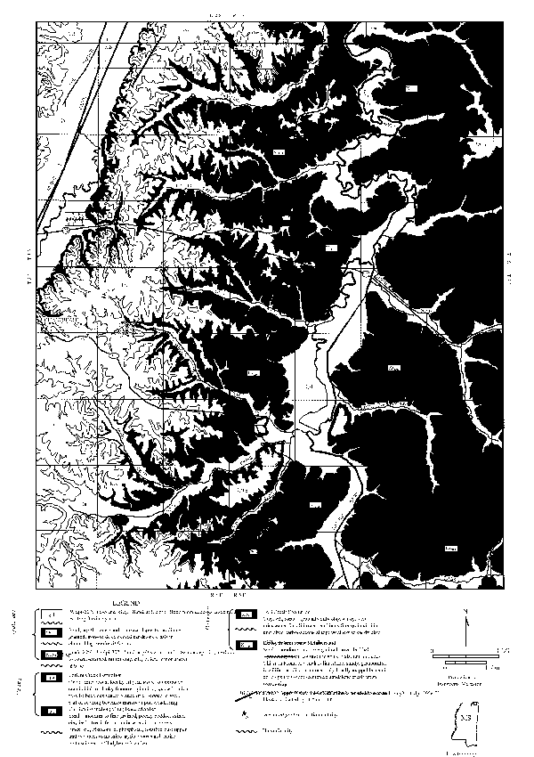
Utility of the Geologic Map--Maps depicting the distribution of geologic units at the surface and the characteristics of these units are useful for a number of purposes. Environmental and municipal planning, the exploration for and extraction of mineral resources are all aided by accurate and updated geologic maps. In the study area, the McNairy Sand is a source of fill materials for construction and road work. The geologic map should serve as a guide to potentially new areas for exploitation of this resource. The displacement of fault blocks may serve as structural traps resulting in the potential accumulation of oil and gas. The locations of fault zones, the first step in identifying a potential structural trap, are of acute interest to Mississippi's oil and gas industry, especially when relatively unexplored, such as the Muddy Creek Fault Zone. Geologic maps may serve as guides to natural hazards such as expansive soils, flooding, and faults which may present earthquake hazards. The Porters Creek Formation, although limited in outcrop in the study area, contains highly expansive soils which pose serious problems to structures founded on them. Care must be taken as to the type of structures located on the flood plains of existing streams (Qal on Figure 3) as these low areas present a flooding hazard. Fault zones may also be sources of seismic activity. Poorly known fault zones, such as the Muddy Creek Fault Zone, should be evaluated with respect to their potential for producing damaging earthquakes. A geologic map can also be used as a guide to determining the location and extent of aquifer recharge areas where care should be exercised to protect groundwater resources.
Periodic revision of geological maps is also desirable in order to reflect changes in stratigraphic nomenclature and changes in the interpretation of various lithostratigraphic units. In the 56 years since Tippah County was first mapped, the understanding of the geologic units present in the county and their correlation with their Gulf Coast equivalents are much better understood. Revised geologic maps contribute to the understanding of the three dimensional geometry of stratigraphic units and their associated geological history.
Structure--Regional strike is north to south with dip rates between 20 feet (6.1 m) and 25 feet (7.6 m) per mile to the west. Local faulting can alter strike directions significantly and dip rates across adjoining blocks can be as much as four times the normal rates of dip. Shearing along the faults creates zones of weakness which coincide with paths of least flow resistance to the local fluvial system. The fluvial system not only follows along the trend of the fault zone, but the fault zone may also control stream and valley morphology as well as flow direction. Anomalous geomorphologic features associated with Muddy Creek and anomalous changes in dip rates across the floodplain can best be explained by displacement along a fault or series of faults oriented parallel to the Muddy Creek flood plain.
Two faults were mapped as part of the northeast trending Muddy Creek Fault Zone. The covered fault located beneath the Muddy Creek flood plain is estimated to have a displacement of approximately 50 feet (15.2 m). The other mapped fault is interpreted to be subsidiary to the larger fault beneath Muddy Creek. Displacement on this fault appears to be less than 20 feet (6.1 m). Other faults probably exist, but a paucity of existing data prohibits their identification or the determination of their orientation(s). The Owl Creek-Clayton exposures at Chalybeate Spring, for example, appear to be unusually low in elevation when compared to the surrounding area, suggesting additional faulting in the Chalybeate area.
Twenty one joint orientations were measured in the fine-grained sediments of the Owl Creek and
Clayton Formations. Most joints are oriented in a northwestern direction and have high angle
dips (greater than 80). Only joints with iron oxide fillings were measured as these joints have a
higher probability of originating from geological processes rather than man-made sources. Joint
location, orientation, and dip are included on the geological map (Figure 3).
CONCLUSIONS
The area encompassed by the Chalybeate 7.5 minute quadrangle contains seven geological units varying in age from Late Cretaceous to flood plain deposits forming presently along existing streams. The Upper Cretaceous McNairy Sand Member of the Ripley Formation is typically a thick sequence of cross-bedded, medium- to coarse-grained sand. A section of clay beds, exposed along the Hatchie River, marks the middle section of the unit. The Owl Creek Formation is the youngest Cretaceous unit and consists of silts and clays with subordinate sand beds. Both Owl Creek contacts are unconformable. The outcrop belts of these two units comprise approximately 63% of the area within the quadrangle. The early Tertiary Clayton Formation consists of a basal, coarse-grained, often gravelly sand, a discontinuous limestone unit, and a medium- to fine-grained, glauconitic sand. The Porters Creek Formation is a finer-grained unit in conformable contact with the older Clayton. The Porters Creek outcrop belt occupies less than one percent of the study area and the Clayton outcrop belt accounts for approximately 13%. Two sets of elevated Quaternary (?) terraces were mapped within the quadrangle. These terrace outliers are typically fining-upward sequences with gravelly sand at the base and silts at the top. Subangular clasts of iron oxide - cemented sandstone appear to be diagnostic of the lower terraces. The higher terrace is represented only as one outlier with its base at an elevation of approximately 590 feet (179.9 m). Approximately 22% of the study area consists of present-day flood plain deposits. These flood plains are well developed along Muddy Creek and the Hatchie River, but most streams of any significant size have an associated flood plain.
The geologic map will serve to aid industry by identifying areas likely to produce economic
amounts of industrial minerals such as sand and areas with the potential for hydrocarbon trapping.
Natural hazards such as flooding, expansive soils and potential for earthquakes can also be
evaluated from the geologic map in Figure 3.
ACKNOWLEDGMENTS
The assistance of Mr. Fazlay Faruque and Mr. Paul D. Mitchell is gratefully acknowledged. Mr.
Faruque, formerly an MMRI Graduate Research Assistant, was instrumental in preparation of the
Arc/Info copy of the geologic map. Mr. Mitchell, MMRI Technical Design Specialist,
constructed the illustrations for this publication. The constructive criticism of Dr. Maurice
Meylan of the University of Southern Mississippi, Mr. Steve Ingram, and Mr. Michael Bograd
both of the Mississippi Office of Geology are greatfully acknowledged.
LITERATURE CITED
Conant, L.C., and T.E. McCutcheon. 1941. Tippah County mineral resources. Mississippi State Geological Survey, Bulletin 42, 228 p.
Dockery, D.T. 1996. Toward a revision of the generalized stratigraphic column of Mississippi. Mississippi Geology, v. 17, no.1, pp. 19.
MacNeil, F.S. 1946. Summary of the Midway and Wilcox stratigraphy of Alabama and Mississippi. U.S. Geological Survey, Oil and Gas Investigation Preliminary Chart 29.
Mississippi Geological Survey. 1969. Geological map of Mississippi. 1:500,000, 1 sheet.
Parks, W.S. 1992. Four levels of terrace deposits and remnants of high-level fluvial deposits in the Hatchie River valley, Hebron area, Hardeman County, Tennessee. Mississippi Geology, v. 13, no. 4, pp. 6370.
Russell, E.E., and W.S. Parks. 1975. Stratigraphy of the outcropping Upper Cretaceous, Paleocene, and Lower Eocene in western Tennessee (including descriptions of younger fluvial deposits). Tennessee Division of Geology, Bulletin 75, 118 p.
Swann, C.T., S.M.R.F. Faruque, and J.L. Harding. 1995. The engineering and environmental geology of the Ripley, Mississippi, area--A guide for small municipalities. Mississippi Mineral Resources Institute, Open-File Report 95-1, 57 p.
Figure 1. Location map. The shaded area represents the Chalybeate, Miss-Tenn. topographic quadrangle.
Figure 2. Stratigraphic column of geologic units cropping out within the study area and a schematic diagram of the elevated, fluvial terraces.
Figure 3. Geological map of the Chalybeate, Miss.--Tenn. 7.5' Quadrangle.